


日本无人机法规:解除在居民区上空自主飞行的禁令
Drone Regulations in Japan: Ban on Automated Flight Over Residential Areas Lifted

前日本总统安倍晋三表示无人机是第四次工业革命的重要部分,日本政府表示大力支持发展商用无人机工业,但是日本无人机法规限制了城市及住宅区的无人机交通。
While the Japanese government has shown support for the commercial drone industry since former Prime Minister Shinzo Abe stated that drones were an important part of the fourth industrial revolution, drone regulations in Japan have limited drone traffic in cities and residential areas.
近日,共同社表示居民区上空自主飞行的禁令已经解除,无人机配送有了更广泛的业务区域。
Now, Kyodo news reports that the ban on automated flights over residential areas has been lifted, clearing the way to more widespread drone delivery.
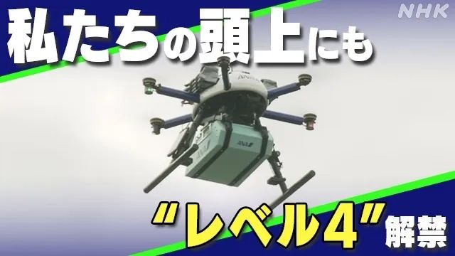
2015年4月,一位反核抗议者使用一架消费级无人机在安倍晋三的住宅地屋顶投放了少量放射性物质,随后便开始严格实施在住宅区上空无人机飞行的禁令。直至今日,日本的无人机法规仅允许自主无人机飞行于无人居住区,包括山脉、河流和农田。
In April of 2015, an anti-nuclear protester used a consumer drone to deposit a small quantity of radioactive material on the roof of then-Prime Minister Shinzo Abe’s residence, prompting the enactment of strict rules about the flight of drones over residential areas. Until today, drone regulations in Japan allowed automated drone flights only over uninhabited areas including mountains, rivers, and farmlands.
有了这些限制,许多无人机送货项目都已在日本部署,农村地区遭受严重的劳动力缺失和供应链困难问题。然而,本次《民用航空法》的修订,为人口更多的地区进行住宅区无人机配送扫清了道路。同时,能采取更加直接的路线让现存的无人机配送项目更有效地进行。
Within those limitations, many drone delivery projects have already been deployed in Japan, which suffers from a serious labor shortage and supply chain difficulties to rural areas in Japan. This revision to the Civil Aeronautics Law, however, will clear the way for residential drone delivery in more populous areas and will allow existing delivery programs to operate more efficiently by taking more direct routes.
为了保障住房上空的安全飞行,政府要求L4级无人机飞行操作者需获得新发布系统颁发的操纵执照,并且他们的无人机需要经政府或者认证机关进行检查和批准。
·To ensure safe flights over houses, the government requires level-four drone flight operators obtain a license issued under a newly launched system and have their drones inspected and approved by the government or certified institutions.
无人机飞行员必须每三年更新其执照,进行笔试和技能测试。在国家指定机构完成课程的人将免于技能测试。
·Drone pilots must renew their licenses every three years by taking written and skills tests. Those who complete courses held at state-designated institutions will be exempt from a skills test.
对于批量生产的无人机模型,每个模型都需要在政府对其产品设计和生产过程检查完成之后给予安全许可。
·For mass-produced drone models, safety approval is given to each model once clearing a government inspection of product design and manufacturing processes.
政府要求用于L4级飞行的无人机每年都需要进行一次试飞。
·The government requires drones used for level-four flights to undergo a flight test every year.
他们的飞行日程和课程都需要提交至政府,操纵者必须就如何解决操作风险和事故报告建立内部指南。发生严重事故时由日本运输安全委员会进行案件调查。
·Theirflightschedulesandcoursesmustbesubmittedtothegovernment,andoperatorsmustcreateinternalguidelinesonhowtodealwithoperationalrisksandreportaccidents.SeriousaccidentswillbeinvestigatedbytheJapanTransportSafetyBoard.
来源:DroneLife
Source: DroneLife

Quantum-Systems和SKYLAB建立合作关系,为林农提供数字森林管理信息
Quantum-Systems and SKYLAB partner to provide foresters with digital forest management information
先进无人机系统创新开发者、设计师和制造商Quantum-Systems GmbH及全数字化森林管理提供商SKYLAB宣布建立合作关系,帮助林业客户最大限度地提高生产力并降低成本。
Quantum-Systems GmbH, an innovative developer, designer and manufacturer of advanced unmanned aerial systems (UAS), and SKYLAB, the fully-digitalized forest management provider, announced a partnership to help forestry customers maximize productivity and reduce costs.
SKYLAB通过深入研究和先进的航空数据分析,提供全数字化森林管理,从幼苗存活和杂草检测到全面木材和碳库存及森林健康监控以及100%的采伐作业。
With deep learning and advanced aerial data analytics, SKYLAB provides fully-digitalized forest management, from seedling survival and weed monitoring to full timber and carbon stock inventories, as well as monitoring forest health and harvesting operations for 100% of the areas. SKYLAB enables its customers to receive precise information on their forestry assets, with 24/7 access to the results online. Paired with aerial data generated by theTrinity F90+ UAV, customers will be able to maximize productivity and optimize management processes.
Quantum-Systems固定翼eVTOL Trinity F90+在德国进行设计和生产,能像一架固定翼飞机般高效飞行,能像一架多旋翼无人机一般进行简易的垂直起降,拥有行业内最广泛的集成传感器选择。该产品提供各种易于互换的相机解决方案,包括MicaSense Altum-PT, MicaSense RedEdge-P, Qube 240激光雷达传感器, Sony UMC- R10C, Sony RX1 RII and the Oblique D2M 相机。此外,Trinity F90+无人机飞行时间达90分钟,远远超过行业标准的60分钟- 让林业专家从仅对森林的 1% 进行采样和推断到能够100%了解一片森林。
Designed and manufactured in Germany,Trinity F90+, the fixed-wing eVTOL from Quantum-Systems flies as efficiently as a fixed-wing aeroplane, allows for easy vertical take-off and landing, like a multi-rotor drone, and comes with the broadest choice of integrated sensors in the industry. Trinity F90+ offers a wide range of easily interchangeable camera solutions, which includes the MicaSense Altum-PT, MicaSense RedEdge-P, Qube 240 LiDAR, Sony UMC- R10C, Sony RX1 RII and the Oblique D2M cameras. Additionally, the Trinity F90+ drone can fly for up to 90 minutes – well beyond the industry standard of 60 minutes – allowing forestry professionals to move from sampling and extrapolating 1% of the forest to knowing 100% of the forest.
结合Quantum-Systems最先进的硬件和SKYLAB先进的林业和种植园管理软件,客户能够获取一个完整的解决方案,,最大化利用Trinity F90+无人机获取的航空数据。使用SKYLABcloud能轻松上传数据、无缝处理、分析和映射并且无需提前了解地理信息系统,客户能够获取其所在国森林精准详细的地图,并整合到他们自己的管理系统。
Combining the state-of-the-art hardware from Quantum-Systems and the sophisticated forestry and plantation management software fromSKYLAB, customers have access to a complete solution that maximizes the usage of aerial data generated by the Trinity F90+ UAV. Using SKYLABcloud for easy data upload, seamless processing, analyzing and mapping, with no prior GIS knowledge needed, customers can generate precise and detailed maps on the state of their forest, to be integrated into their own management systems.
林农使用高精度的SKYLAB地图能够减少其运营成本,最大限度地提高生产力,通过确定种植存活率低的区域、精准选择播种填充物、最小化化学物质和机械投入,监控病害区和问题区,优化采伐作业,大大提高收益性。
Using the highly accurate SKYLAB maps, foresters reduce their operating costs and maximize productivity by identifying areas of low seeding survival, targeting seeding refill, minimizing chemical and mechanical input, monitoring disease and problem areas, and optimizing harvesting operations, which all results in significantly higher profitability.
来源:sUAS News
Source: sUAS News