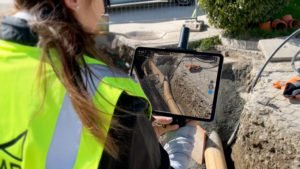

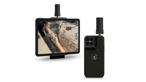
Photogrammetry solutions leader Pix4Dhas just released the viDoc RTK rover in the USA and Canada. Previously released in Europe, the German-designed rover connects to the latest iOS devices in order to bring RTK accuracy to terrestrial scanning on iPhones and iPads.
The viDoc rover and PIX4Dcatch solution is able to eliminate the need for burdensome and costly survey tools such as RTK GNSS rovers and terrestrial scanners, and is available at a significantly lower price point.
“The viDoc RTK is a very easy-to-use handheld device used to 3D model just about any small area or structure. Combined with processing in PIX4Dmatic with both LiDAR and photogrammetry data, it’s an exciting new and accurate product,” said VerticalAspect’s Mark Paulson, a professional surveyor with 30 years of experience and a decade of experience working with drones and photogrammetry in surveying.
When the viDoc RTK is integrated with the PIX4Dcatch mobile app, the two products form a workflow that transforms iPhones or iPads into an accurate terrestrial scanning device, providing centimeter-accurate RTKpositioning from the user’s existing NTRIP network. Additionally, PIX4Dcatch utilizes LiDARscanners in the latest devices, which are also used during data capture and processing to improve scale and completeness. This culminates in a survey-grade tool in the pockets of professionals, replacing heavy LiDAR scanners and rovers.
The viDoc RTK rover for PIX4Dcatch is made to be combined effortlessly with all of Pix4D’s photogrammetry solutions. The accessible workflow allows users to go from scanning a site in minutes with the viDoc rover and PIX4Dcatch to processing on the cloud with PIX4Dcloudfor 3D-models and volume measurements. Users also have the option of processing the data from PIX4Dcatch in the desktop software PIX4Dmatic and making use of both LiDAR and photogrammetry data to obtain the desired outputs, which can be added to PIX4Dsurvey for vectorization and be made ready for CAD.
The convenience, output quality, and affordable price offered by the viDoc RTK rover possess the ability to revolutionize the AEC industry and lead new workflows to industries such as public works, accident reconstruction, and stockpile management.